Cross Country Skiing
On the Bizz Johnson Trail – Westwood to Susanville
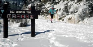
There are quite a few opportunities for Nordic Skiing around Lassen National Forest. Northern California recieves a large amount of moisture throughout the winter, and therefore snowfall.
Your local office of the US Forest service offers maps and information which include several trails in Lassen, Plumas, Sierra and other counties. Cross country skiing is considered strenuous exercise and as with any exercise, you should check with your doctor first. Practicing in a meadow near the car is probably a good idea for beginners. It is good to remember to pace yourself and watch those slopes because wherever you go, you also have to get back!
Following the old Fernley and Lassen Branch Line of the Southern Pacific railroad, the trail winds 25.4 miles from Susanville to Mason Station. For the first 16 miles, the trail follows the Susan River. As it winds through the rugged Susan River Canyon, the trail crosses the river 12 times on bridges and trestles and passes through two tunnels.
. The trail begins at 4200′ on the east side of the Sierra and Cascade Ranges in Susanville, climbs 1300′ to a high point of 5500′ at Westwood Junction then drops 400′ to its terminus in Westwood at elevation 5100′. Check current conditions before planning a trip on the trail by calling (530) 257-0456.
CROSS COUNTRY SKIING
A recommended trail segment on the Bizz for cross-country combines snowed-in road skiing from Highway 44 to Goumaz (three miles) with trail skiing from Goumaz to Highway 36. This nine-mile segment affords a gentle downhill slope with good views of the Susan River and Diamond Mountain. To avoid backtracking, arranging your own shuttle is recommended.
The lower seven miles of trail from Highway 36 east to Susanville can be skied following major snowfall, but snow conditions deteriorate rapidly on this section due to lower elevations and open southern exposures. Also, two tunnels (one 800 feet, the other 450 feet) require walking.
The best public access areas are at:
* Mason Station near Westwood
* Highway 44 near Hog Flat Reservoir
* Highway 36 near Devils Corral
* Susanville Trailhead
Before beginning a cross-country skiing expedition, check local weather conditions.
SPRING FISHING ON THE TRAIL
Fishing in the Susan River is best in spring to early summer. The river provides habitat for rainbow and brown trout, speckled dace, lahontan residue, and Tahoe sucker. Twice monthly in May, June, and July, the California Department of Fish and Game plants rainbow trout in the lower Susan River between Susanville and Devils Corral. Stocking of fish generally ends in July when river temperature peaks reach 70-75 degrees Fahrenheit.
CROSS COUNTRY SKI SAFETY
* Always tell someone where you are going and how long you plan to be gone. Use registration boards where provided.
* Weather conditions can change rapidly in the mountains. Before heading out, get an updated weather and avalanche report from the Forest Service or other appropriate agency. A topographic map and compass are recommended for unmarked trails.
* Don’t go alone – and make sure that you and your partner or group are able to meet any conditions that may arise.
* Skiing over frozen lakes and rivers may be hazardous and is not recommended!
* Be prepared with the proper clothing by dressing in layers. If you get warm, take off the top layer. When you stop, put it back on. By controlling your body temperature you will be comfortable and avoid hypothermia.
* Hypothermia is a rapid and progressive mental and physical collapse resulting from lowering the inner temperature of the human body. Hypothermia can cause death. Prevent it with proper clothing, food and water. Avoid overexertion, eating snow or drinking alcohol.
* Frostbite is caused by exposure of flesh to subfreezing temperatures and can be a precursor to hypothermia. If it is cold enough to freeze flesh, you should reconsider your ski trip.
* Are you physically fit? Make each trip a comfortable and fun excursion. Don’t go so far you struggle to get back.
* Questions? Contact the Forest Service.
Maps, Facts & Photos courtesy USDA Bureau of Land Management, www.srs.fs.usda.gov »
< –>